
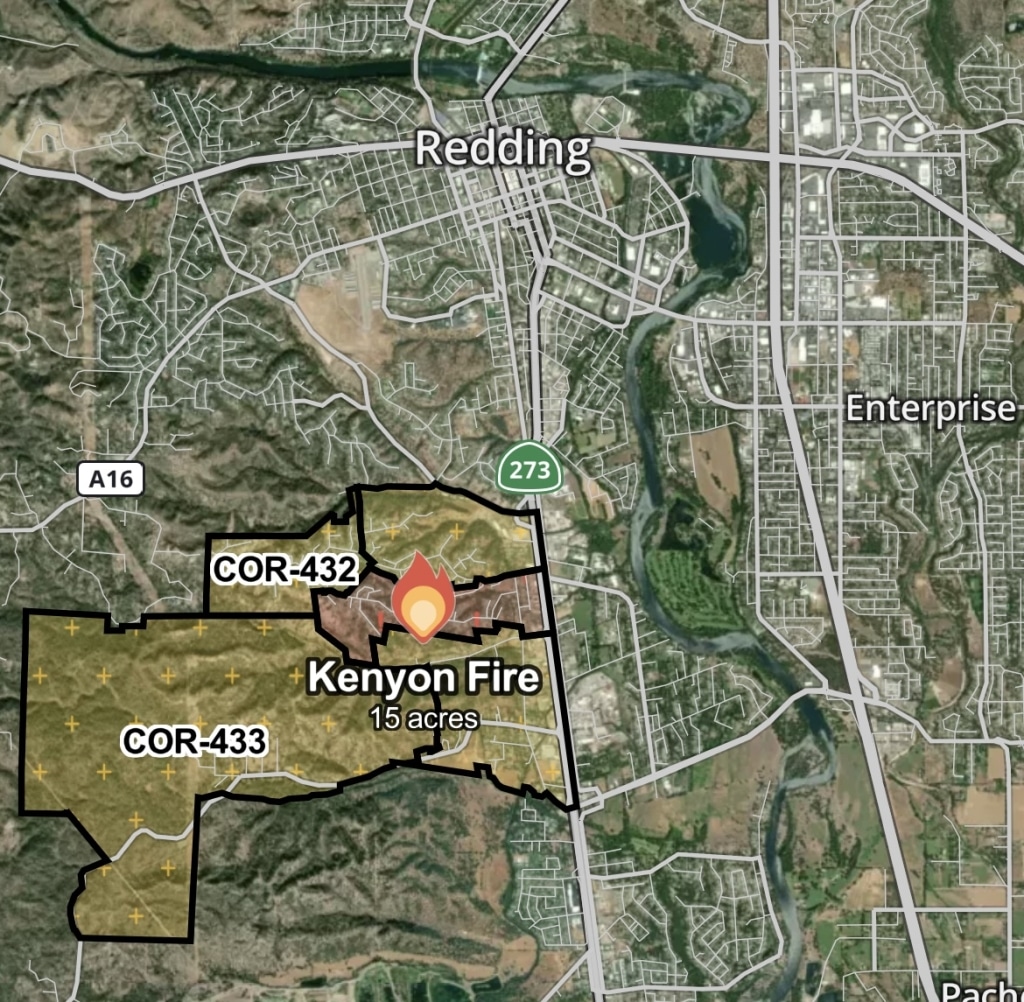
Evacuations Ordered for Kenyon Fire in Redding
The first has grown to 15 acres in the last hour.
Update 4:45 Evacuation warnings for zones COR-431, COR-432, COR-433, and COR-435 have been lifted. An evacutation order for COR-434 remains in place.
Update 3:22 pm: The fire has reached 26 acres, per Cal Fire.
A fire that started around 1:45 pm this afternoon, June 29, in the Kenyon Drive area of Redding has grown to 15 acres. The fire has prompted evacuation orders and warnings.
Evacuations have been ordered in zones COR-434. An evacuation order means you should leave now. Find your zone here.
Evacuation warnings have been issued for zones COR-431, COR-432, COR-433, and COR-435. If you’re in a warning zone, prepare to leave if ordered.
For those at risk, the best sources for urgent information are Watch Duty and Cal Fire.
This is developing coverage. Check back for updates.
Do you have a correction to share? Email us: editor@shastascout.org.
Author

Comments (1)
Comments are closed.
Related Articles
A private developer and a former city planning manager could be the next to join the Redding Planning Commission
Neither of the prospective candidates mentioned environmental concerns in their applications, a perspective that’s been missing since two commissioners were replaced last year.

Endangered salmon returned to California’s far north — then the money dried up
Newsom promised to help a Native tribe restore sacred salmon to their ancestral river. Now California is ending the funding. The fish made it back to their ancestral waters for the first time in 80 years — so why is California walking away now?

Congressional District 2 hopefuls court Shasta voters ahead of June primary
Candidates for California’s District 2 congressional seat — which will represent Shasta under newly-drawn Prop. 50 lines — appeared in Redding for a forum last night. The audience questioned candidates about immigration, voting rights, the environment and how much time they’d spend in Shasta.
The piece is entitled, “Location of Kenyon Fire via watch duty” But the given “map” shows no street names other than 273.