
Three bears, three months: Highway 299’s cost to wildlife
Three bear deaths since midsummer mark a troubling pattern on Highway 299 which threads through prime bear habitat.
This story was originally published in The Trinity Journal. It is republished with permission.
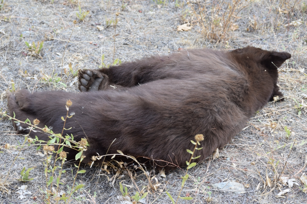
On Monday morning, Oct. 20, a black bear yearling lay on the westbound shoulder of Highway 299 near Whiskeytown Lake, just past mile marker 16.69. The sun had barely crested over the oaks and pines that line the canyon slopes, the air still cool and resin-scented. Traffic was already moving fast — trucks and commuters bound for Redding, tourists heading west toward the coast, and locals on their way to work to and from Weaverville. The bear’s dark fur was easy to miss in the patchy light, another casualty on one of Northern California’s most traveled mountain highways.
It was the third dead bear spotted since midsummer. In late July, another young bear was struck and killed just a few miles up the road near Trinity Mountain Road. Then, in September, a yearling was found near Lewiston, west of the Trinity River, along the same winding route. Together, the three deaths mark a troubling pattern on a highway that threads through prime bear habitat — and a reminder of the uneasy overlap between wildlife and drivers.
A rising trend
Wildlife-vehicle collisions are increasing across California, particularly for large mammals like black bears that roam the forested slopes and river canyons of the North State. According to the UC Davis Road Ecology Center, bear collisions are rising by roughly 10 percent each year. Between 2016 and 2022, more than 1,000 black bears were reported killed on state highways, and researchers say the true number may be several times higher.
Beyond the loss of wildlife, these crashes pose real risks to drivers, especially on narrow mountain roads like 299, where a blind curve can leave little room to react. As California debates where to invest in fencing and wildlife crossings, the recent bear deaths along this corridor underscore the stakes for both wildlife and the people who share the road with them.
A string of incidents
The first bear appeared July 28 near Trinity Mountain Road inside Whiskeytown National Recreation Area. This reporter observed the animal lying off the westbound lane, and state agencies were notified soon after.
A spokesperson for the California Department of Fish and Wildlife said Caltrans typically removes road-killed wildlife and urged drivers to file reports either through the agency’s online Wildlife Incident Report system or directly with the California Highway Patrol.
Six weeks later, on Sept. 10, another young bear was struck near mile marker 66.25 westbound outside Lewiston. CHP confirmed that no crash report was filed, though motorists are encouraged to call 911 after collisions with large animals, particularly when damage exceeds $1,000.
Then came Oct. 20. Traveling to Redding for an appointment, this reporter spotted the yearling near Whiskeytown Lake just after 8:30 a.m. and submitted a report to CDFW. The agency later said staff hadn’t reached the site in time to collect DNA samples before road crews removed the carcass.
Three bears in less than three months — all along the same 20-mile corridor between Whiskeytown and Lewiston — a stretch that cuts across the edge of the Shasta-Trinity National Forest and through some of the region’s most active bear habitat.
Hot highways
Fraser Shilling, director of the Road Ecology Center at UC Davis, said that while CHP is often first to respond to crashes involving animals, many incidents go unreported.
“If we get reports for 200, then there’s probably between 800 and 2,000 actually occurring,” Shilling said.
The likelihood of a collision depends not only on traffic but on habitat. “(Highway) 299 crosses through good bear habitat, there’s always plenty of bears around to get hit,” he said. “Any of the highways that cross the North Coast Range, the Sierra Nevada, the Siskiyou or Klamath mountains — all of those areas, you can expect black bear collisions.”
Bear crashes are less about isolated hotspots, he added, and more about “hot highways” — long rural stretches cutting through intact habitat.
Why bears are moving more
The increase in bear collisions doesn’t necessarily mean there are more bears. It could mean they’re moving farther and more often in search of food.
“Sometimes when we see an increase in roadkill for a predator, it doesn’t necessarily mean the population is booming,” Shilling said. “It might mean they’re hungrier and moving more because their food is scarcer.”
He noted that deer collisions are declining — a likely sign of shrinking deer populations — while bear and mountain lion strikes are rising, suggesting a broader ecological shift. Along corridors like 299, where oak woodlands meet conifer forest, bears forage for acorns, berries and carrion. A poor food year or habitat loss can push them closer to the pavement.
Population pressures
CDFW estimates the state’s black bear population at 49,000 to 71,000. Even so, Shilling warns that human-caused mortality can tip healthy populations toward decline.
“Cars aren’t predators – they’re something completely new,” he said. “No species has evolved to handle that kind of loss.”
Bears already face pressures from food scarcity, habitat loss and disease. Each highway fatality means fewer chances to breed and fewer young dispersing across the landscape. “When you throw cars on top of everything else,” Shilling said, “you’re getting to something unsustainable for almost any animal.”
The cost to drivers
Shilling said the average property-damage-only crash in California costs about $13,000.
“If you throw in injury crashes and fatalities, that number goes up significantly — into the hundreds of thousands,” he said.
Because of their size, bears can total a car, and swerving to avoid them can be just as deadly on 299’s blind curves. “I would swerve to avoid hitting a bear,” he said, “but it also puts you at greater risk of having a fatal accident.”
Anyone who’s driven between Weaverville and Redding knows there’s little margin for error on those grades.
Statewide solutions
According to the 2023 California Roadkill Hotspots Report by UC Davis, mitigation strategies such as wildlife-barrier fencing and animal-crossing structures remain the most reliable ways to reduce collisions.
At more than 300 miles long, Highway 299 is California’s third-longest state route, winding through forests, river valleys and steep canyons. Fencing, Shilling said, could guide animals toward existing culverts and bridge underpasses. “There are a lot of existing ways for bears to get across the highway without going over top,” he said. “The fencing stops them from getting onto the road, and the culvert or bridge is the way for them to cross.”
The UC Davis report notes roughly $1 billion in state funding has been allocated across agencies to plan and build wildlife-movement projects. Shilling said that while the state’s recent $100 million commitment marks progress, the overall need remains “a multi-billion-dollar problem.”
Public reporting, community role
For most wildlife collisions, the state only knows what people report. The California Roadkill Observation System run by UC Davis, depends on volunteers, agency staff and drivers to log where animals are struck. Each report helps scientists identify danger zones and push for fixes.
Shilling said that while documenting roadkill can feel grim, public reporting through CROS is a “a big part of how we even know there’s a problem.” On remote stretches of 299, where traffic is lighter and cell service spotty, every submission matters.
Local residents who encounter dead wildlife can file quick reports through CROS or the CDFW portal. Those entries help determine where fencing, signage or speed studies might someday appear.
For Trinity County, where the road doubles as both commuter route and wildlife corridor, local eyes remain the first line of data collection.
Big picture
Each black bear killed on 299 tells a larger story — of fragmented habitat, rising traffic and the tension between mobility and ecology in Northern California’s backcountry. Scientists at UC Davis call roads like 299 “linear ecosystems,” meaning they don’t just pass through nature, they reshape it. Every culvert, bridge and guardrail alters how animals move, hunt and survive.
For Shilling, the fate of a single bear connects directly to the health of California’s wild landscapes. “Every time we kill an animal in the woods,” he said, “we stop a connection, we stop dispersal, we stop reproduction. We keep a wild species from being wild.”
Statewide, efforts to restore those connections are taking root — through crossings, fencing and the growing recognition that roads themselves can be redesigned to work for both people and wildlife. But along Highway 299, progress will depend on local advocacy as much as funding or engineering.
Three bears in three months — each a reminder that Highway 299 is both a road through wilderness and a mirror of how fragile the wilderness has become.
Francisco Martínezcuello covers science, environment, and indigenous communities for The Trinity Journal through the California Local News Fellowship initiative.
Do you have information or a correction to share? Email us: editor@shastascout.org.
Comments (6)
Comments are closed.
Related Articles
Killing of armed Minneapolis protester Alex Pretti ignites 2A debate in conservative Shasta County
Second Amendment supporters in Shasta County including some with connections to a local militia, weigh in on topics including the right to carry at protests and the federal government’s current approach to immigration enforcement.
Race for Shasta’s District 5 gets crowded as Anderson council member Mike Gallagher announces candidacy
Gallagher, who’s in his second term on the Anderson City Council, joins former Supervisor Tim Garman and current Supervisor Chris Kelstrom in a race for the seat. The three will face off during the primary in June.
Activist sentenced to three months for disrupting Shasta County board meeting, released with ankle monitor
Jenny O’Connell-Nowain was recently convicted for meeting disruption after a peaceful protest at the county boardroom. Today, a visiting Shasta County judge sentenced her to three months in jail. She’s already been released on house arrest, with an ankle monitor.
My daughter’s friend hit a Cub on 299 last night. No damage or injuries to truck or passengers. The Cub did not survives
I’m a little confused about what kind of wildlife or roadkill people should report on, is it all no matter what size or species that is on the bigger scale? There are always dead skunk 🦨 s on the roads and that would be impossible to report all small ones. It would be nice if they could make a animal overpass crossing on 299 near Whiskey lake
Not to mention squirrel.
The deaths of black bears in California are taken into consideration as to the number of black bears that can be harvested (a soft word for, killed) by hunters in California. The black bear hunting season is set by start-and-stop dates but can end earl when a certain number of bears are harvested by hunters. Trinity County is a top-three county for bear harvesting: hunting and vehicle deaths are not threatening the population of bears.
There is no mention of the impact of “grows” on wildlife.
Great story and focus on bears. I want to point out that contributing a roadkill report to CDFW’s system may be useful to CDFW, but they don’t share data well, so the data may disappear into a data black hole. The California Roadkill Observation System (CROS, https://wildlifecrossing.net/california) shares data through direct requests and through an online portal (https://crosplan.wildlifecrossing.net). If you want your public data to stay public, share with CROS.