
Zeke Lunder Explains the Shoe Fire
Lunder, a mapping specialist who’s worked in wildfire for thirty years, says the area affected by the Shoe Fire is remote and will benefit from a slow steady burn as the National Forest Service works to put the fire out.
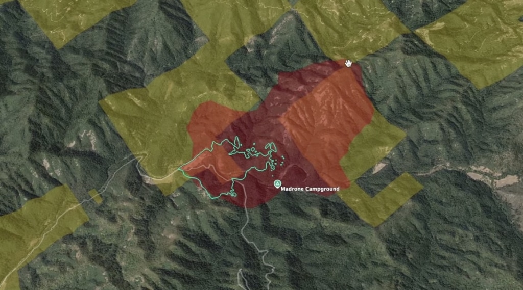
The Shoe Fire started on October 9 and has burned almost 1,400 acres in a remote part of Shasta County. Little public information has been released about the Shoe Fire since it began. We reached out to Zeke Lunder of The Lookout to learn more.
Scout: Can you explain your professional background and why you’re qualified to share information about wildfires?
My name’s Zeke Lunder. I’ve been working in wildfire in northeastern California for 30 years and as a mapping specialist on large fires for the last 25. I’m also a California state prescribed-fire burn boss with a background in large-fire management.
I’m the director of Deer Creek Resources. Our company is currently writing Shasta County’s community wildfire protection plan and we just finished the same document for Redding. We use mapping and our experience to help develop fuel reduction projects, prescribed burns and other projects that increase wildfire literacy and community wildfire resilience.
On the side, I run The Lookout, a media company that shares features on active fires, forestry and rural culture via our website, YouTube channel and on Twitter.
Scout: What can you tell me about the area where the Shoe Fire is burning?
It’s burning halfway between Route 299 and Highway 5, between Round Mountain and Lakehead and it’s burning in what’s called checkerboard ownership land. When they built railroads, they gave away every other square mile of land on each side of the railroad. In this case the checkerboard extends about 20 miles on either side of the highway itself.
Scout: How many people live in this area?
Hardly anyone lives out there. I’m guessing within ten miles of the fire there might be fifty houses, including cabins. It’s super remote. There’s only one main road through there, Fenders Ferry Road. A lot of the Forest Service land out there is actually mapped as roadless. And then there are roads on the private timberlands, which are owned by Sierra Pacific Industries. There’s been some logging in this area but a lot of this area was logged a really long time ago. Since then, in the last thirty years, the Forest Service has done very little on this land. A lot of what grows on this land is oak. It’s not all pure pine trees and fir trees, it’s a mix of conifer and other kinds of forest.
Scout: So there’s a lot to burn out there?
There’s a lot to burn but fire activity is very mild right now and in my opinion, the land is going to benefit from the Shoe Fire. Where there’s a lot of oak trees, there’s a lot of litter that’s made up of a lot of oak leaves on the forest floor that haven’t been cleaned up for a long time and need to be.
Scout: Is the fire likely to grow quickly?
This isn’t like the Carr Fire where it’s going to run to 10,000 acres tomorrow. The weather is cooling off and getting more humid and the fire hazard risk is going down each day. Things are dry out there but the days are short so there’s less time each day where the conditions are promoting active burning.
There’s potential for the fire to make localized runs. It could run a few hundred acres when the sun’s out, but it’s not going to spread much more than that given current conditions. If we were looking at a forecast with strong dry winds blowing for an extended amount of time, that would be different. But unless we have a big wind event, it won’t spread fast. It might burn steadily and double in size every day. But it’s only 1700 acres now, so even with doubling it’s not going to get that big.
Scout: Who’s managing this fire?
The California landscape is divided up into what we call Direct Protection Areas, which designate who’s going to be the lead agency when a fire burns there. The Shoe Fire area is a federal direct protection area, so it’s being run by the National Forest Service. With checkerboard land ownership, fires end up being under Unified Command, meaning there will be a Forest Service representative and a Cal Fire representative who’ll make decisions jointly. And because there’s so much private land mixed in out there, they’re going to try to suppress it as much as they can, even if the fire is good for the Forest Service land.
Scout: How do they determine the size of the fire and when do they update the public?
Lately they’re flying more and more infrared flights during the day to look at the fire. This allows us to find the perimeter, which can then be fed into mapping software to determine acreage. The National Fire Service publishes a perimeter feed that comes out in real time as infrared imaging is interpreted.
So fire experts are able to watch the fire size pretty closely, but the public doesn’t always get the information as fast. Right now, that’s because national fire management is currently at what’s called Preparedness Level 5, the highest of our 5 levels. Resources are spread super thin because of how many big fires are burning and that leaves barely any fire management teams with communications people available to respond to smaller, less dangerous fires like this one.
There are also a limited number of public information officers that are qualified to work on these federal teams and a lot of them have been on back-to-back fire duty since June. Resources are also impacted by a lengthening fire season. The Forest Service system still relies heavily on seasonal labor and with climate change pushing extraordinary heat and big fires into October, that’s breaking the system we have.
Scout: What kind of response is going to be most needed for the Shoe Fire?
The Forest Service can call on Cal Fire as needed. But there’s very few roads out there, so that means a very limited amount of work can occur with fire engines. What they will need if the fire grows is more hand crews. And that’s an especially thin resource, but again fire activity is very mild right now.
Scout: What else would you like to share with the community about the Shoe Fire?
I think in general, people should understand that this area where the fire is burning needs fire. It’s remote and we have very few other tools to actively manage the vegetation of the landscape in places like these. So fire is totally appropriate for managing this land and the fire conditions we’re having now are good enough for a prescribed burn. This would actually be a great place to be conducting a prescribed burn if it wasn’t quite so dry and if the Forest Service had more resources.
So what people should understand is that the more we put out fires like this that are doing good ecological work, the more we increase the risk of a destructive fire later. When we’re super aggressive about putting a fire like this out, we’re moving the risk of destructive fire down the road to future generations and guaranteeing that we’ll have worse fires later.
We’ve actually seen similar fires in the area in the past, including the 2012 Bagley Fire that burned 45,000 acres and a lot of that area is healthier now. So it’s important to remember that even under bad conditions fire is not guaranteed to be highly destructive in this landscape and it’s a necessary and important part of the ecology.
Resource:
The Shoe Fire – Seeing the Bigger Picture – via The Lookout
Do you have a correction to share? Email us: editor@shastascout.org
Author

Comments (21)
Comments are closed.
Related Articles
Lake Redding Golf announces reopening and new driving range
The golf course has been closed the past several months while its owner, The McConnell Foundation, figured out improvements and changes to the site.
After most recent school board appointment, Jackie LaBarbera faces new legal challenge
A community member has submitted a legal challenge to the state over the dual roles school board member Jackie LaBarbera has held since January 2025. The challenge was submitted not long after LaBarbera was temporarily appointed to a third school board role last week.
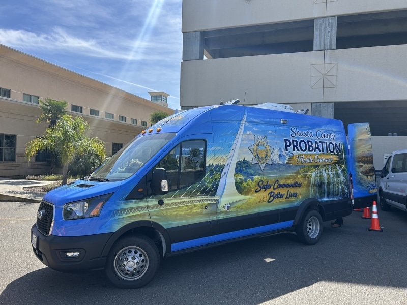
Shasta launches Mobile Probation Vehicle program to remove barriers for those living in rural areas
The MPV will be used to provide services to people who are unhoused or live in rural areas to help them successfully comply with the terms and conditions of their probation. It’s funded by a more than $280,000 state grant.
https://www.shastacounty.gov/clerk-board/page/meeting-videos
Begin at 1:30 minutes
Have a nice retirement, Jones.
I find it very interesting that the “cause”” and “effects” are being extremely down played. I have several friends that work in not only local fire departments, but those who work for CalFire as well. They have given a much different perspective as to the reality of why the Shoe Fire has occurred. What has been relayed to me, is that it was actually a prescribed burn that got out of control, and is still going strong with 0 containment.
This begs the question, as to who would’ve recommended a prescribed burn in an area in a Preparedness Level 5 zone? The true answer is no one.
Not to mention, the effects of a 300+ AQI for those who live in Shasta County, where the smoke settles- such as Redding and surrounding areas. This is considered hazardous and extremely unhealthy for everyone, especially the elderly, and those who suffer with respiratory and weakened immune systems.
This can cause serious issues ranging from respitory failure, cardiac arrest, as well as an uptick in mortality rates for those exposed to the Covid 19 virus. None of this is remotely mentioned.
The “expert” mouthpiece for this article, is truly a genius for passing the buck onto the so called “benefits” for Shasta Trinity’s ecological system. Bravo to you Mr. Zeke on this excellent twist upon such a serious situation. Politics at its finest.
As I previously had mentioned, this is not coming from mere speculation, yet straight from firefighters/CalFire members themselves. I was in Redding for a two day visit, and the smoke was enough to drive me out. I was also a previous resident of Redding and have experienced many fires due to different causes, which are always consistently covered and analyzed by the local news.
This is a ridiculous take on the reality of the situation. I find it astonishing that no one is questioning the ambiguity of what truly caused this fire.
I have recently moved south to SLO County, and am grateful that my asthma and my father’s cancer will not be affected by these fires. Not to mention the pathetic coverage of an incident that will, in all actuality, be very harmful for the public who are living under these conditions. Oh yes- don’t forget about the heavy metal particulates that will linger for decades to come. 👍🏼🙄
Jess: Mr. Lunder wasn’t asked about the cause of the fire (which he wouldn’t be in a position to know) or the related health concerns from wildfire particulates (which is not an area that he has any expertise in.) While it’s interesting that you have heard such specific information from firefighters about the cause of the fire, the US Forest Service has not shared this kind of information with the public, at least not yet. I agree that there is still much to be learned about this fire and its startling how little we know.
Why wouldn’t you ask him? As an investigating reporter, I’d expect more than questions to be asked. Were you told not ask specifics? I’m just curious “Oh what a tangled web we weave, when when we first practice to deceive”. just saying…
Hi Jess, No one told me not to ask specifics and if they did that wouldn’t have stopped me lol. I simply focused on the limited scope of expertise this individual has when I spoke to them for this specific interview. As more continues to come out I continue to report.
Sorry, voice text ought not be used in a comment.
And thank you for your transparency. 👍🏼
In the recent past we’ve witnessed people being prosecuted long before the fire was out,it’s no secret that this was a prescribed burn,as people were told that when they called to report it,there should be accountability across the board,when we have to call to burn our fuels,the air quality is always a factor,in this situation nobody has taken into consideration public safety knowing full well the smoke was going to attack the entire north state.and shouldn’t you let the people surrounding the fire know long before you burn at a time when fire dangers are extreme,anyone who downplays this fire has no regard for public safety,perhaps you should find a more suitable career,maybe something you could be good at,you all have failed the surrounding residents and by letting it burn at this time of year is absurd.i only hope your families aren’t affected the way we are with the threat of a controlled burn being on the edge of being even more out of control than you let it get already and the A.Q.I.i will give you job well done in keeping the cause secret which speaks volumes , you will lose much sleep knowing you nade a bad decision and you better pray no firefighters or public are killed or injured.
Dowen: Hi there. Who specifically are you referencing when you say they are keeping the cause secret?
Thank you for the confirmation. Prescribed burn is xxactly how LE deals with cartel grows they have ignored for years. Check out “Hidden War” https://www.amazon.com/Hidden-War-Operations-Reclaiming-Wildlands/dp/1946267619 . This information is “enlightening” and will give rural folks a tool to not only understand what is really going on, but who to call early on in Spring that will deal with the problem as opposed to ignore it. We the People are not stupid. We the People deserve better. The 50 plus residence in this area, We feel your grief.
Note: the initial cause was propagandized as “unknown”. Patrick Jones, District 4 Stuporvisor was just talking about this very subject a few days prior to ignition. October 1st or 8th. He stated he was going to talk with Sheriff Johnson in reply to Supervisor Rickerts discussion on “illegal grows” and wanted to know specifically “where” in the county this activity was being propagated, literally.
In these games there are no coincidences.
It’s interesting that there is no mention of cartel grow saturation in this area more or less the county(s) in general. When you see the vehicles that are burnt, license plates removed, vin numbers torched, windows and windshields bashed out… this is the signature of cartel activity and human trafficking. Non due diligence by local law enforcement, MIT/ MET operations for years contributes to this burden on the public. The Forest Service, Cal Fire and BLM can not manage it themselves. Are you “following” Sheriff Johnson? It’s nice to see that you have a small team this season. Outdoor recreationists are well aware of the dangers associated with cartel operations… get’er done or retire so someone with the will and community in mind can handle it. There is plenty of evidence I’ve photographed on both ends of Fenders Ferry Road recently to verify what I’m saying here more or less you could ask any resident in the area. Ask Supervisor Jones… he knows.
Thank you for this excellent article. We live 12 miles due east of the Shoe fire surrounded by sierra Pacific, PG&E and federal forest land that has not been managed since replanted after the Fountain Fire in 1991. I wonder what the responsibilities of timber owners might be to manage these lands that are dense with brush and trees?
They used to manage them regularly until the environmental groups shut the logging down in California. Ironically in 1991 via the spotted owl. These massive fires never used to happen when we actively harvested and replanted our timber. Everyone wants to blame climate change on these fires and divert blame from the real cause, which is horrible government policies that allowed our timberlands to get overgrown.
I bet those that own the 50 homes/cabins would like air tankers to drop fire retardant on their homes and surrounding area.
Frank: always good to remember those most impacted.
True story! Thank you for acknowledging this, as I failed to mention this in my scathing comment that is still under “moderation review”. Let’s see if they actually believe in the freedom of speech that the press so desperately demand.
This is a very good and informative article Annelise. Keep up the good work.
As I recall, wasn’t Lewiston burnt down by a managed 2 acre burn, wasn’t a third of Lassen Park burnt down by a managed fire 10 or so years ago? Numerous destructive have gotten away from managed burns. Buy an electric car to offset the carbon pumped into the atmosphere by these managed burns.
Why is it called *shoe fire”? Is there a shoe Creek or shoe mountain or some such? Thank you.
As the owner of a USFS Residential Recreational lease lot in Didallis Tract 2, I am always concerned about Shasta/Trinity National Forest fires, Especially those seven miles away. I am encouraged by the description of the Shoe as a very mild active fire. FYI the Shasta-Trinity District Ranger just denied (Aug. 26) my request to install an additional 1500 gallon water tank even though I agreed to install with USFS compatible hardware so their ground crews could access and utilize to facilitate fire control in an attempt to better secure the cabin our family has leased for 69 years.
It is nice to hear from an expert about the benefits of fire in forests and woodlands when the weather is cooler and homes aren’t threatended. Now if the USfS can just resist the pressuer to allow salvage logging in the area.