
Redding City Council moves forward with Riverfront Specific Plan
With little debate, the council unanimously voted this week to advance the development plan for the Redding riverfront. Once finalized, the document will set the boundaries for how development could occur on prime public land.

The Redding City Council voted unanimously at Tuesday night’s meeting to advance the Redding Riverfront Specific Plan.
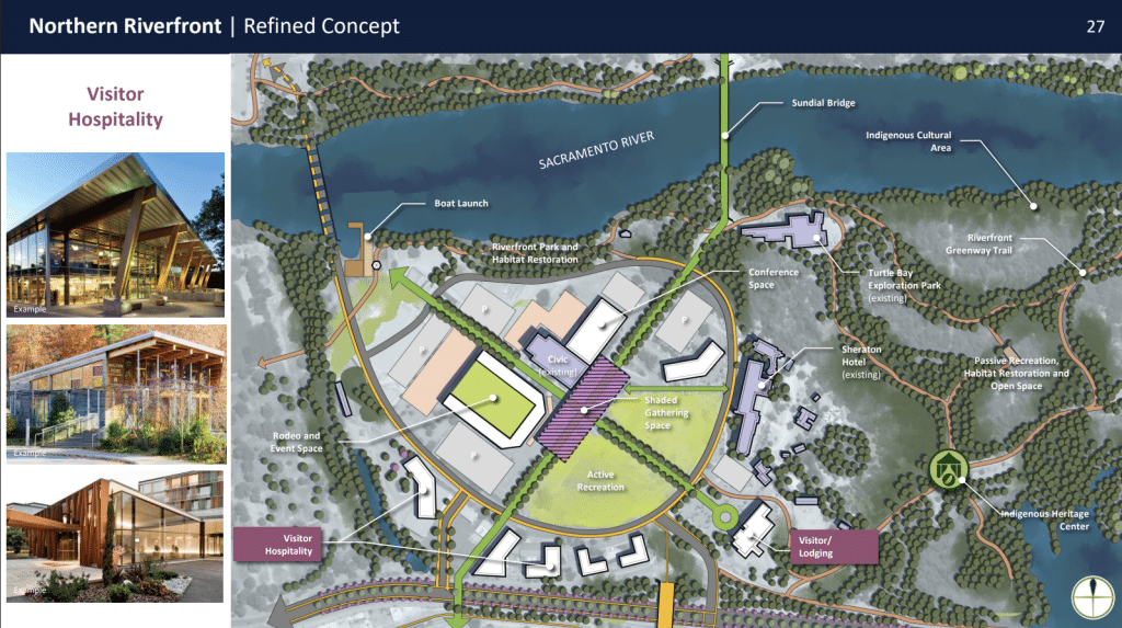
The area that’s become known as the Redding riverfront includes a 380-acre section of private and public land and water along the Sacramento River in the heart of downtown Redding. The Sundial Bridge, Civic Auditorium, Turtle Bay and Park Marina Drive are among sites included in this area.
The specific plan has been in discussion for several years as the city works to update boundaries around development in the area amid public concerns dating back to 2021 about how public land at the riverfront could be utilized. In public discussions, terminology has been used to divide the Redding riverfront roughly into two sections: the mostly publicly-owned northern riverfront and largely privately-owned southern riverfront.
This past May, the city council pushed back against some concepts in an initial draft plan for how riverfront land might be used in future — specifically, a proposed transformation related to Highway 44 as well as housing that was proposed in the northern riverfront area.
At Tuesday night’s meeting, the council took a second look at the plan after revisions from staff in response to the feedback this spring. Council members said their concerns had largely been addressed, with several voicing their appreciation for the changes made by city staff.
Redding Development Services Director Jeremy Pagan said in an email statement today that the specific plan does not include residential use of the northern riverfront, but that “visitor retail” zoning would allow for features like hotels and restaurants. He added that secondary access to the northern riverfront will remain a concept in the plan, but an exact route hasn’t yet been determined.
The changes made by staff after the May city council meeting where the specific plan received pushback were not included in the agenda packet for Tuesday’s meeting, leaving the public without awareness of what exactly the council could move forward this week.
Pagan said this was because the refinements were “very minor in nature,” and the specific plan was being worked on until the last minute. He said the staff report recommendation was framed as an “Accept presentation from staff…” — meaning staff generally provide “a limited scope of information in the staff report and provide the bulk of the rest of the information and details at the meeting with the presentation itself.”
“Importantly, the Council did not approve anything on Tuesday,” Pagan continued, “they simply gave staff the green light to begin drafting the language of the plan.” He made note that the public will have opportunities to provide feedback over the next six months while the plan is being finalized.
Council member Dr. Paul Dhanuka was the only one hesitant to advance the updated plan shared with the council Tuesday night — he initially said he wanted more time to review details and give the public a chance to provide feedback given that information in the presentation hadn’t been provided to the public before the meeting. But he quickly fell in line with the other council members, while adding that he wants future presentations and plans the council votes on to be provided to council members in advance.
The council’s vote accepted the specific plan concepts presentation given at the meeting and authorized city staff to move forward with the plan in line with the currently-proposed direction for how boundaries will be established for the use of riverfront land. Doing so will include “developing draft specific plan language and initiating the environmental review process.”
Background of the Redding Riverfront and its specific plan
Public conversation about the riverfront began in the fall of 2021, when a real estate negotiation scheduled during a city council meeting involving a proposal to develop public riverfront land sparked months of public pushback.
Much of the public’s outrage had to do with a lack of transparency in how the prime land was identified on the council’s agenda — only by parcel number — as well as the proposal itself. The following April, council member Erin Resner motioned for larger discussions on the riverfront development, and the council agreed to fund a $1.25 million update to the Riverfront Specific Plan.
In the years following, city staff met repeatedly with community members and the city council to develop the plan, which will form a legally-binding document when complete that includes design guidelines for buildings, analysis of infrastructure capacity and circulation guidelines for transit.
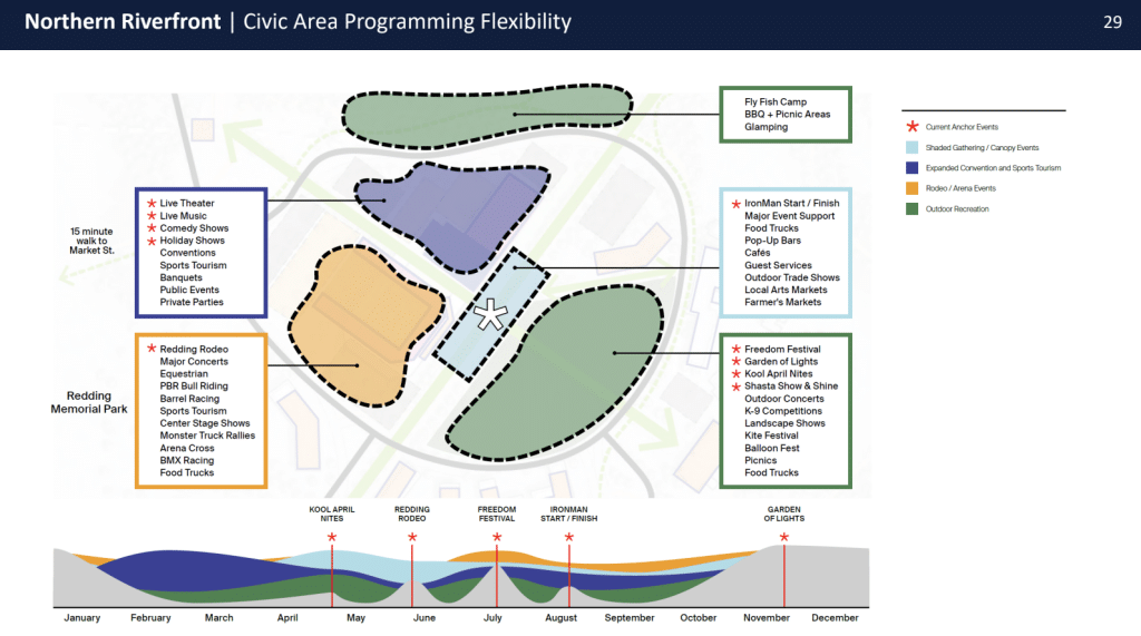
The current draft plan is divided between the northern and southern portions of the riverfront, and it prioritizes environmental health, Indigenous cultures and entertainment. The northern riverfront concepts include remodeling the Redding Rodeo Grounds and Civic Center, habitat restoration and improving vehicle and pedestrian access. For the southern riverfront, which is largely privately-owned, city staff plan to focus on “water-oriented” development like swimming, boating and fishing.
When it comes to the draft specific plan’s focus on Indigenous cultures, Tuesday’s presentation included strategies to develop partnerships with local Tribes and Indigenous communities to “co-steward public open space areas” and create a Tribal Heritage Center and Tribal Cultural Space. The land the Redding Riverfront sits on was originally owned by local Tribes.
Now that the council has voted to advance the specific plan, city staff will form a draft of the specific plan document based on the concepts shared this week, discuss that plan with the community and council, then approve a final plan, which could happen in the spring of 2026. Since the final plan hasn’t been approved yet, the specific plan concepts discussed at Tuesday night’s meeting aren’t concrete and haven’t been set in motion.
You can find the presentation to the city council on the proposed riverfront development here.
Do you have information or a correction to share? Email us: editor@shastascout.org.
Comments (12)
Comments are closed.
Related Articles
Congressional District 2 hopefuls court Shasta voters ahead of June primary
Candidates for California’s District 2 congressional seat — which will represent Shasta under newly-drawn Prop. 50 lines — appeared in Redding for a forum last night. The audience questioned candidates about immigration, voting rights, the environment and how much time they’d spend in Shasta.
Documents show the Shasta Sheriff’s Office attempted to enter an agreement with ICE last year. Doing so would have violated state law
The sheriff’s office took actions to enter what’s known as a 287(g) agreement with ICE last May, but the process appears to have been halted. ICE’s 287(g) program, which gives local and state officers immigration enforcement authority, has been making national headlines.

After the resignations of three board members, Cascade Union Elementary School District gains a new one: Jackie LaBarbera
Following a dispute with the superintendent, the majority of CUESD board members resigned over the last week. Shasta County Office of Education Board President Michael Orlicky has appointed SCOE Board Vice President Jackie LaBarbera to fill one of the empty seats, ensuring a quorum.
What nobody is talking about is the plan to “Decommission Highway 44 and build traffic lights and roundabouts”. This is the worst aspect by far.
“that “visitor retail” zoning would allow for features like hotels and restaurants.”. Most of our local population will probably be priced out of the hotels and restaurants that would be built there. How about for every plan designed to accommodate, ‘moneyed interests’, there needs to be an offset plan to accommodate the portion of our populace who live paycheck to paycheck? Like affordable campgrounds and services along side of the same river? Up or down stream would be fine.
Since the sales tax failed, what will happen with the civic auditorium? Without the sales tax, it might have to close
I attended the meeting and most of the others. Many people in the audience wanted to make comments/ask questions but except for Dhanuka council members were in a hurry to get to the next stage and just wanted to approve this regardless. He argued with them before capitulating. What you didn’t mention in your report were the sparse details they mentioned about the south side. The presenters rapidly glossed over most of the south end which frustrated the audience (many spoke about this outside).
Thanks for this feedback, Shirley.
I have a major eye roll for every time we must consult with “the tribe.” It’s the same exhausted reaction triggered by Bible quotes. Ridiculous. Did you know that Indigenous people used to own the land under Jiffy Lube and In N Out?
NC: Interesting take. Do you know what Tribal consultation occurs?
Does anyone? “Co-steward” is a feel good term, but that land is too valuable to share decision making for Redding’s growth with people who want to talk about their great great great great great grandmother smoked salmon somewhere. Spoiler alert, they were living and using every square foot of both sides of he river from Dunsmuir to San Pablo Bay. You cannot walk anywhere without tripping over someone’s bones. Tribes made war and replaced other tribes, took slaves and were assimilated. There is no one group that has a superior moral claim to being a better custodian of the land. Just look at what is veing proposee down off Bonnyview. Build a shrine to Massacre Flats if you think it’s there (it isn’t, it’s 20 miles south, but whatever, dont let the details get in the way of a great casino off ramp). Just miss me with the indigenous people and the bible references.
NC: I’d encourage you to learn more about the Native people still living on, and stewarding, our community’s land today.
I suggest the same to you. Sentimentality vs pragmatism.
I’m still not clear. Is there a possibility either now or later for Riverfront housing? I’m contacting the Council as well. Riverfront housing is not something the people want. Either now or slipped in later.
Bobby, We’ve been told there will be no housing at the northern riverfront.